Information
about the Kefalonia Island
Back to Ionian Islands || Back
to CorfuToday
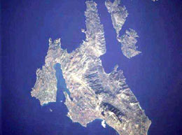
Kefalonia is the sixth largest
Greek island (781,5 km2, 250 km coastline) and together with Ithaca
and the surrounding islands it forms the largest district in the
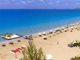
Ionian archipelago. An unusually undulating coastline, unique
natural scenery, beautiful beaches, diverse vegetation, rare fauna
as well as the size and history of the island, where nature truly
excels, make it interesting for everyone.
According to mythology, the island took its name from the Athenian
leader and warrior Cephalos. Another version says that thanks
to its size and political significance, this island has always
naturally been considered the head of all the Ionian islands (kefali=head
in Greek).
The island with approximately 38 000 inhabitants is predominantly
mountainous and has the highest mountain range of Enos, whose
highest peak Ainos (Mega Soros) at 1 628 metres above sea level
is the highest on the Ionian islands. A relatively good asphalt
road which gradually becomes an unmaintained track will lead you
through a natural reserve with forests full of the protected Kefalonian
fir almost to the peak of this mountain.
|
|
An unforgettable view, with the near and
distant surroundings as if on the palm of your hand, will be your
reward for this difficult climb. In ancient times there was a
temple devoted to Zeus at the top of Ainos, but unfortunately
nothing remains of it due to several earthquakes.
Also characteristic of Kefalonia are the many fertile plains where,
thanks to the high number of sunny days, vines, from which the
famous local Robola wine is made, flourish. |
|
It is well-known that the demand
for this wine all over the world greatly exceeds the supply. Thanks
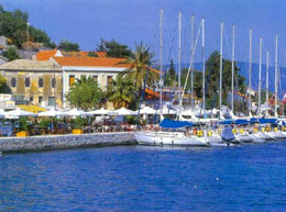
to plant and animal produce and above all shipping, Kefalonia
has maintained an economic independence since ancient times. Tourism
is, therefore, a welcome but by no means essential source of income
for most Kefalonians.
Kefalonia is often described as an island of contrasts and if
you manage to see at least some of the interesting places, then
you will surely agree that this description is justified. |
The driving force came from the water in
the sea which poured through the ravines in the chalk cliffs into
unknown depths and did not emerge into the light of day until
the village of Karavomilos not far from Sami. The route of these
waters was discovered in 1963 by Austrian geologists, who dyed
the water, which emerged near Sami 14 days later. The former strength
of these currents, which were responsible for keeping huge mill-wheels
in motion, was destroyed by an earthquake in 1953. |
Another place of interest is
the so-called fathomless lake of Avythos (also Akoli) near the
village of Agios Nikolaos. When you are wearied by travelling
and the scorching sun, you have the unique opportunity to plunge
into the cool interior of the earth and admire the magnificent
stalagmites and stalactites in the Drogarati (Dragon) Caves.
The caves are thought to be 150 million years old. Because of
the perfect acoustics the caves are also used for concerts. |
|
You can take part in a boat tour on the lake
in the Melissani Caves which are near the village of Karavomilos
and which were not discovered until the year 1953 when their ceiling
collapsed during an earthquake. The sunbeams which pour into the
cave play a wonderful game with colours on the surface of the
lake. Another exceptional phenomenon on the southern promontory
of the Pali peninsula was a moving rock, whose movement increased
when the sea was rough. This movement ceased following the earthquake,
however according to geologists a smaller neighbouring rock has
begun to move. The nearest village is called Kounopetra (which
in Greek means 'moving stone'). |
© Corfutoday.com -
Travel and Holiday Guide
All Rights Reserved. No part of this web site may be reproduced
without permission.
|
|
|